


Paragliding Map
Description of Paragliding Map
Paragliding Map is a mobile application designed for paragliding enthusiasts, providing essential information and tools for both planning and executing flights. This app serves as a comprehensive resource for users seeking real-time data on weather conditions, launch sites, and much more. Available for the Android platform, users can easily download Paragliding Map to enhance their paragliding experiences.
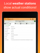
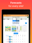
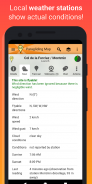
The application features real-time weather station data sourced from various providers including Pioupiou, Holfuy, MADIS, and FFVL. This ensures that users have access to current weather conditions, which are crucial for safe and successful paragliding. The inclusion of forecasts from multiple weather services, such as Meteoblue, Windy, and WindFinder, further assists users in planning their flights.
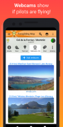
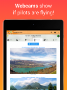
Users can explore over 15,000 launch sites, 7,500 landing spots, and access information from 30,000 weather stations and 39,000 webcams. This extensive database provides a wealth of information, allowing paragliders to find suitable locations for their activities. The app also includes features such as airspace and NOTAMs, which inform users about short-term airspace restrictions. These tools are indispensable for ensuring compliance with regulations and maintaining safety during flights.
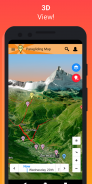
The interactive capabilities of Paragliding Map include a 3D view, which offers a unique perspective of the terrain and surroundings. This feature aids in visualizing launch sites and understanding the landscape better. Additionally, the app provides 'Hike & Fly' trails, enabling users to locate and navigate trails that can be used for paragliding adventures.
Driving directions to each spot are available within the app, allowing users to easily find their way to launch locations. The navigation feature integrates with GPS, providing precise directions and making trips more efficient. Moreover, users can save their favorite spots for quick access later, streamlining their planning process.
Paragliding Map also supports advanced search functionalities, enabling users to filter the map based on various criteria such as wind speed, public transport availability, and specific types of flying like thermalling or soaring. This tailored search capability allows users to discover locations that meet their individual preferences and requirements.
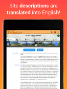
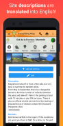
For enhanced convenience, the app includes automatic translation of site descriptions into English, making it accessible to a wider audience. This feature is particularly beneficial for international users who may not be familiar with the local language. Users can easily share spot and map details through social media platforms such as Facebook and Twitter, facilitating communication and information sharing within the paragliding community.
Safety is a priority for paragliders, and Paragliding Map addresses this need by allowing users to send SOS messages and ride requests to friends, complete with GPS coordinates. This feature enhances safety measures by enabling quick communication in case of emergencies.
The app also boasts a wind animation feature, which allows users to visualize clouds, thunderstorms, rain, and wind conditions at various altitudes. This visual representation aids in understanding weather patterns, which is crucial for making informed decisions about flight conditions.
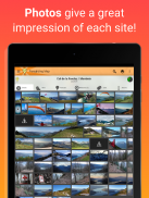
Images and photos are integrated into the app to provide users with a clear impression of each spot. These visuals can help users evaluate launch sites before they arrive, ensuring they are prepared for their paragliding experience.
Paragliding Map offers full support for users, addressing any inquiries or issues they may encounter while using the app. This commitment to customer service helps foster a positive user experience and encourages feedback for continuous improvement.
The app is free to use, with features supported by advertising. However, users have the option to make in-app purchases, which will disable advertisements and provide access to additional features such as webcams and forecasts. This flexibility allows users to choose the level of access that best fits their needs.
With an extensive range of features, Paragliding Map serves as an invaluable tool for paragliding enthusiasts. From real-time weather data and extensive site information to advanced search capabilities and safety features, the app is designed to support users in their paragliding endeavors. By integrating various functionalities into one platform, it aims to cater to the diverse needs of the paragliding community.
For more information, you can refer to the privacy policy and terms and conditions available at https://www.paraglidingmap.com/TermsAndConditions.aspx.
Paragliding Map - APK Information
APK Version: 11.7.0Package: com.paraglidingmapLatest Version of Paragliding Map
Other versions


Apps in the same category


